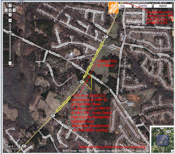
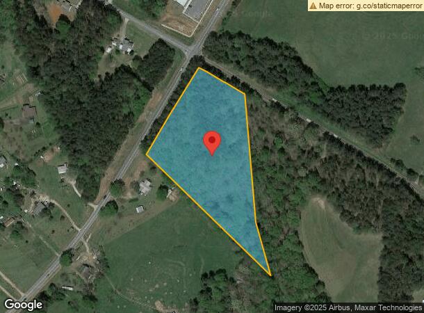
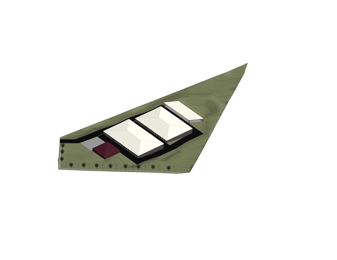
Property Record
682 Tanners Bridge Rd, Bethlehem, GA 30620

NEARBY LISTINGS FOR SALE OR LEASE
Property Detail
682 Tanners Bridge Rd
Atlanta-Sandy Springs-Roswell, GA
Regency Park
XX054-037
PB 6-380 TR 4B
Commercialacreage
Barrow
A
Georgia
13297C0020F
res
2024
6 AC
2024
Barrow County
180503
Atlanta
DEMOGRAPHICS near 682 Tanners Bridge Rd
1 Mile
3 Mile
5 Mile
2024 Total Population
3,742
19,987
39,445
2029 Population
4,394
23,132
45,302
Pop Growth 2024-2029
+ 17.42%
+ 15.74%
+ 14.85%
Average Age
34
36
37
2024 Total Households
1,196
6,485
12,853
HH Growth 2024-2029
+ 17.56%
+ 15.88%
+ 15.14%
Median Household Inc
$65,106
$73,318
$77,757
Avg Household Size
3.10
3.00
3.00
2024 Avg HH Vehicles
2.00
2.00
2.00
Median Home Value
$202,350
$229,795
$245,956
Median Year Built
2004
2003
2001
Nearby Places
- Restaurants
- Banks
- Shops
- Fitness
- Groceries
SALE & LEASE HISTORY
LISTING DATE
SALE/LEASE

Sep 24, 2016
For Sale
Nearby Properties
Address
Land Use
TOTAL SIZE
Lot Size
Zoning
Address
Land Use
TOTAL SIZE
Lot Size
Zoning
10,128 SF
28.20 AC
R-3
Address
Land Use
TOTAL SIZE
Lot Size
Zoning
26,789 SF
35.60 AC
C-3
Address
Land Use
TOTAL SIZE
Lot Size
Zoning
22,320 SF
15.90 AC
R-3
Address
Land Use
TOTAL SIZE
Lot Size
Zoning
120,000 SF
142.70 AC
AG
Address
Land Use
TOTAL SIZE
Lot Size
Zoning
2,046 SF
13 AC
B-2,R-3
Address
Land Use
TOTAL SIZE
Lot Size
Zoning
132,156 SF
10.10 AC
C-2
Address
Land Use
TOTAL SIZE
Lot Size
Zoning
79,029 SF
9.70 AC
C-2
Address
Land Use
TOTAL SIZE
Lot Size
Zoning
37,162 SF
4.60 AC
R-3
Address
Land Use
TOTAL SIZE
Lot Size
Zoning
104,805 SF
12.50 AC
C-3
Address
Land Use
TOTAL SIZE
Lot Size
Zoning
1,188 SF
7.60 AC
R-3
Address
Land Use
TOTAL SIZE
Lot Size
Zoning
38,550 SF
3 AC
C-2
Address
Land Use
TOTAL SIZE
Lot Size
Zoning
46,339 SF
2 AC
B-2
Address
Land Use
TOTAL SIZE
Lot Size
Zoning
45,296 SF
8.20 AC
B-2
Address
Land Use
TOTAL SIZE
Lot Size
Zoning
19,483 SF
2.80 AC
B-2
Address
Land Use
TOTAL SIZE
Lot Size
Zoning
153 AC
R100
Address
Land Use
TOTAL SIZE
Lot Size
Zoning
2,398 SF
8.10 AC
R-3
Address
Land Use
TOTAL SIZE
Lot Size
Zoning
18,240 SF
1 AC
B-2
Address
Land Use
TOTAL SIZE
Lot Size
Zoning
14,300 SF
5.80 AC
M-1
Address
Land Use
TOTAL SIZE
Lot Size
Zoning
4,026 SF
1.60 AC
B-2
Address
Land Use
TOTAL SIZE
Lot Size
Zoning
14,356 SF
2.30 AC
B-2
Address
Land Use
TOTAL SIZE
Lot Size
Zoning
1,395 SF
0.16 AC
HPM2*
Address
Land Use
TOTAL SIZE
Lot Size
Zoning
13,439 SF
1.30 AC
B-2
Address
Land Use
TOTAL SIZE
Lot Size
Zoning
14.70 AC
C-2
Address
Land Use
TOTAL SIZE
Lot Size
Zoning
10,455 SF
2 AC
B-2
Address
Land Use
TOTAL SIZE
Lot Size
Zoning
23,378 SF
9.60 AC
M-1
Address
Land Use
TOTAL SIZE
Lot Size
Zoning
3,600 SF
3 AC
C-3
Address
Land Use
TOTAL SIZE
Lot Size
Zoning
11,928 SF
1 AC
B-2
Address
Land Use
TOTAL SIZE
Lot Size
Zoning
6,345 SF
1.80 AC
B-2
Address
Land Use
TOTAL SIZE
Lot Size
Zoning
10,688 SF
0.90 AC
B-2
Address
Land Use
TOTAL SIZE
Lot Size
Zoning
13,775 SF
4.40 AC
C-2
The World's #1 Commercial Real Estate Marketplace
Connect with us
© 2025 CoStar Group
The information above has been obtained from sources believed reliable. While we do not doubt its accuracy we have not verified it and make no guarantee, warranty or representation about it. It is your responsibility to independently confirm its accuracy and completeness. Any projections, opinions, assumptions, or estimates used are for example only and do not represent the current or future performance of the property. The value of this transaction to you depends on tax and other factors which should be evaluated by your tax, financial, and legal advisors. You and your advisors should conduct a careful, independent investigation of the property to determine to your satisfaction the suitability of the property for your needs.